News Summary
Charleston, SC, has faced significant flooding due to record-breaking rainfall from severe thunderstorms. With nearly 2 inches reported at local airports, public safety is a concern as flooding warnings extend across surrounding areas. As conditions remain unstable, communities are advised to stay vigilant amid ongoing weather disturbances impacting the Southeast.
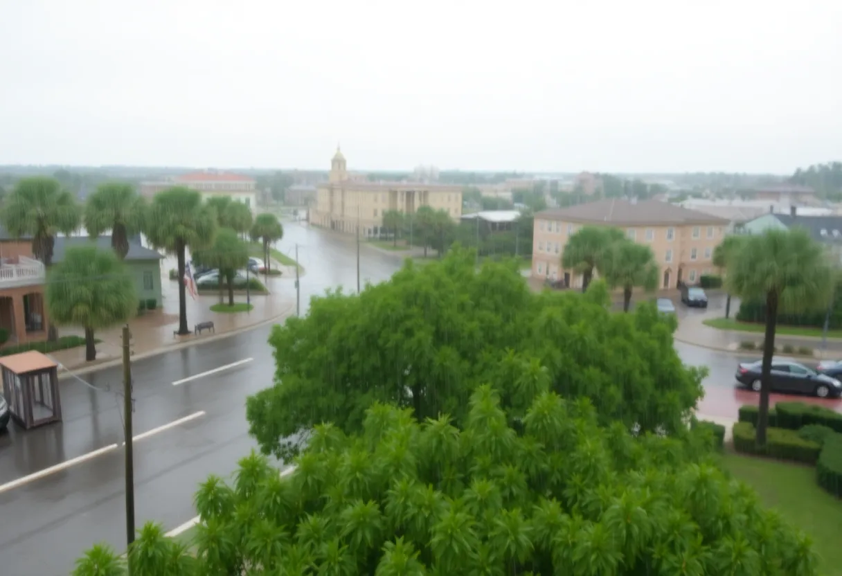
Charleston, SC has experienced significant flooding caused by severe thunderstorms that brought record rainfall on Sunday. The National Weather Service had earlier issued severe thunderstorm warnings for Jasper and Beaufort Counties, which expired at 3:45 p.m. A second warning for Orangeburg County ended at 4:30 p.m. Although the warnings have expired, strong thunderstorms are still possible in the region through the evening, particularly between 3 p.m. and 9 p.m.
Charleston International Airport reported a remarkable 1.99 inches of rain since midnight on Sunday, breaking the city’s previous May 11 record of 1.93 inches, which was set in 1952. Downtown Charleston recorded even higher rainfall, with 2.06 inches falling since midnight, surpassing the former record of 1.57 inches established in 1899. As a result, areas across Charleston and surrounding regions faced severe flooding, raising public safety concerns.
Regional weather disturbances have not only impacted Charleston but have also led to issued Flash Flood Warnings across several parts of Alabama, Florida, and South Carolina. These warnings have since expired but highlighted the widespread nature of the crisis. The National Oceanic and Atmospheric Administration’s Weather Prediction Center has indicated a Level 2 flood threat across the Southeast and mid-Atlantic, impacting millions.
As the storm system progressed, Florida and southern Georgia faced particular threats of heavy rainfall and the potential for flooding. In fact, the Northwest Florida Beaches International Airport recorded a staggering 0.75 inches of rain in just eight minutes, indicating a rainfall rate of 5.63 inches per hour. Reports suggest that some areas may receive total rainfall exceeding 4 inches as thunderstorms linger into the weekend.
The storm system is expected to drift into the Tennessee Valley by Monday, continuing its path to bring rain to the Carolinas and Virginia. Forecasts indicate that rainfall totals of 3-5 inches are anticipated for most areas, with localized totals reaching as high as 7 inches in parts of western North Carolina and Virginia. To further complicate the situation, Flood Watches are anticipated to expand as conditions develop early in the week.
Weather patterns in South Carolina will remain unsettled, with the possibility of isolated storms expected each afternoon and evening through Wednesday. A strong cold front is projected to move through the state on Wednesday, leading to more rain and thunderstorms. Additionally, windy conditions are anticipated, with gusts recorded at up to 35 mph on both Wednesday and Thursday.
As temperatures fluctuate due to the approaching cold front, daytime highs are predicted to drop to the upper 60s and lower 70s, while overnight lows should settle in the 50s. Residents in the affected areas have been urged to stay alert and prepare for changing conditions as the storms evolve over the coming days.
With ongoing concerns about potential flooding, authorities are closely monitoring the situation, encouraging community vigilance as further weather developments unfold in the wake of this weekend’s severe thunderstorms.
Deeper Dive: News & Info About This Topic
HERE Resources
Charleston Enhances Coastal Resilience with Seawall Completion
Charleston and Jersey Shore Set for Beautiful Weekend Weather
Charleston’s Legal Battle Against Oil Companies Over Climate Issues
Charleston’s Arts Scene Thrives Amidst Variable Weather
North Charleston Police Seize Modified Firearm and Marijuana
Charleston Celebrates Cultural Vibrancy This Weekend
North Charleston Elects New Council Members Amid Scandals
Charleston Faces Severe Weather and Artistic Events
Severe Flooding Hits Charleston, South Carolina
Charleston Faces Increased Localized Flooding Due to Recent Thunderstorms
Additional Resources
- Herald Online: Weather News
- Wikipedia: Severe Thunderstorm
- Live 5 News: First Alert Storms
- Google Search: Charleston Weather Alerts
- Fox Weather: Flash Flood Threat
- Encyclopedia Britannica: Weather Patterns
- WYFF4: Storms and Tornado Threat
- Google News: Severe Weather South Carolina
Author: STAFF HERE CHARLESTON
The CHARLESTON STAFF WRITER represents the experienced team at HEREcharleston.com, your go-to source for actionable local news and information in Charleston, Charleston County, and beyond. Specializing in "news you can use," we cover essential topics like product reviews for personal and business needs, local business directories, politics, real estate trends, neighborhood insights, and state news affecting the area—with deep expertise drawn from years of dedicated reporting and strong community input, including local press releases and business updates. We deliver top reporting on high-value events such as the Spoleto Festival USA, Charleston Wine + Food Festival, and the MOJA Festival. Our coverage extends to key organizations like the Charleston Metro Chamber of Commerce and the Charleston Museum, plus leading businesses in tourism and maritime industries that power the local economy such as South Carolina Ports Authority and the Charleston Visitor Center. As part of the broader HERE network, including HEREaiken.com, HEREbeaufort.com, HEREchapin.com, HEREcharleston.com, HEREclinton.com, HEREcolumbia.com, HEREgeorgetown.com, HEREgreenwood.com, HEREgreenville.com, HEREhiltonhead.com, HEREirmo.com, HEREmyrtlebeach.com, HEREnewberry.com, HERErockhill.com, HEREspartanburg.com, HEREaustin.com, HEREcollegestation.com, HEREdallas.com, HEREhouston.com, and HEREsanantonio.com, we provide comprehensive, credible insights into South Carolina's dynamic landscape.