News Summary
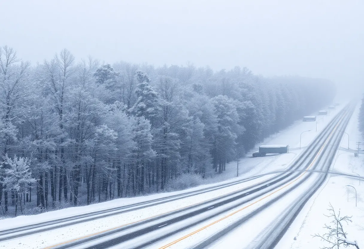
A significant winter storm is predicted to bring potential snowfall to various regions of South Carolina, including Columbia. The National Weather Service warns of dangerously cold temperatures, with highs in the 30s and lows plunging into the teens. Snow accumulation is expected to range from one to three inches, particularly south of Interstate 20, prompting travel advisories and caution from local utilities regarding power outages and hazardous conditions. Residents are urged to stay updated through weather alerts and avoid unnecessary travel during the storm.
South Carolina
Wintry weather, including potential snowfall, is forecasted for Columbia and various regions across South Carolina this week. The National Weather Service (NWS) predicts that cold temperatures and a winter storm will impact the area starting Sunday night, with temperatures remaining low throughout the week.
As a cold front moves into the state, high temperatures are expected to remain in the 30s, while lows could plunge into the teens. A significant drop in wind chill values is also anticipated, with conditions possibly feeling as cold as below 15 degrees overnight. The coldest temperatures are predicted to occur from Tuesday through Thursday.
Snowfall possibility across South Carolina, especially south of Interstate 20, has been assessed at increasing levels from Tuesday into Wednesday. Forecasts estimate snow accumulation ranging from one to three inches in many areas, while the NWS has expressed high confidence that most of the state will experience snowfall during this period. A winter storm warning has already been issued from midnight on February 11 until 9 p.m. on February 12, with forecasts suggesting that multiple inches of snow could fall through most of Wednesday.
Significant Weather Impacts
The Midlands, Lowcountry, and Pee Dee regions are expected to bear the brunt of this winter weather event, while the Upstate area is likely to be less affected. A “highly impactful” winter storm is anticipated, prompting warnings from the NWS about hazardous road conditions, frozen pipes, and dangerous circumstances for those without adequate shelter. Travel during this winter storm is strongly discouraged, as multiple inches of snow could lead to treacherous driving conditions.
Columbia has taken proactive measures by preparing snowplows and other necessary equipment ahead of the storm forecasted for Wednesday. An additional emphasis is placed on the need for residents to avoid travel during severe weather and to remain vigilant for warnings regarding road conditions.
Utilities and Public Safety Measures
Columbia Utilities has mobilized extra crews for potential downed power lines during the storm. With the possibility of sleet and freezing rain accompanying the snowfall, especially south of Boone County, precautions have been set in place to ensure public safety and effective management of resources.
Snow accumulation is forecasted to be particularly heavy on Wednesday, with maximum totals predicted to reach as high as seven inches in some areas. Moreover, light accumulations of up to one inch could occur on Tuesday evening. The probability of receiving at least 2 inches of snow is estimated at 79%, with a 52% chance of six inches or more falling by the end of the storm.
Additional Considerations
With temperatures expected to rise above freezing on Friday, Columbia anticipates a high of around 37 degrees, which may assist in melting some of the accumulated snow. However, as conditions shift again by Sunday, temperatures are projected to fall, leading to potential refreezing conditions and the risk of black ice due to low temperatures dipping into the 20s.
Residents can sign up for winter weather alerts via Smart 911 to stay updated about the conditions. To facilitate efficient snow removal, Columbia has designated priority snow routes and maintains 1,450 lane miles, with 691 of those being prioritized for response during winter weather. Even when conditions do not allow for full snow clearance, streets are deemed passable if one lane is plowed, ensuring accessibility during severe weather.
This winter storm marks the potential third significant snow event of 2025 in Columbia and its surroundings, an area where such snowfall is uncommon. The last noteworthy snowfall occurred in January 2022, with measurable accumulation recorded at up to 3 inches.
Deeper Dive: News & Info About This Topic
- Columbia Missourian
- KOMU
- Columbia Tribune
- ABC 17 News
- Post and Courier
- Wikipedia: Winter storm
- Google Search: winter storm Columbia South Carolina
- Google Scholar: winter storm effects
- Encyclopedia Britannica: winter storm
- Google News: winter storm Columbia

Author: STAFF HERE CHARLESTON
The CHARLESTON STAFF WRITER represents the experienced team at HEREcharleston.com, your go-to source for actionable local news and information in Charleston, Charleston County, and beyond. Specializing in "news you can use," we cover essential topics like product reviews for personal and business needs, local business directories, politics, real estate trends, neighborhood insights, and state news affecting the area—with deep expertise drawn from years of dedicated reporting and strong community input, including local press releases and business updates. We deliver top reporting on high-value events such as the Spoleto Festival USA, Charleston Wine + Food Festival, and the MOJA Festival. Our coverage extends to key organizations like the Charleston Metro Chamber of Commerce and the Charleston Museum, plus leading businesses in tourism and maritime industries that power the local economy such as South Carolina Ports Authority and the Charleston Visitor Center. As part of the broader HERE network, including HEREaiken.com, HEREbeaufort.com, HEREchapin.com, HEREcharleston.com, HEREclinton.com, HEREcolumbia.com, HEREgeorgetown.com, HEREgreenwood.com, HEREgreenville.com, HEREhiltonhead.com, HEREirmo.com, HEREmyrtlebeach.com, HEREnewberry.com, HERErockhill.com, HEREspartanburg.com, HEREaustin.com, HEREcollegestation.com, HEREdallas.com, HEREhouston.com, and HEREsanantonio.com, we provide comprehensive, credible insights into South Carolina's dynamic landscape.