Charleston, September 7, 2025
News Summary
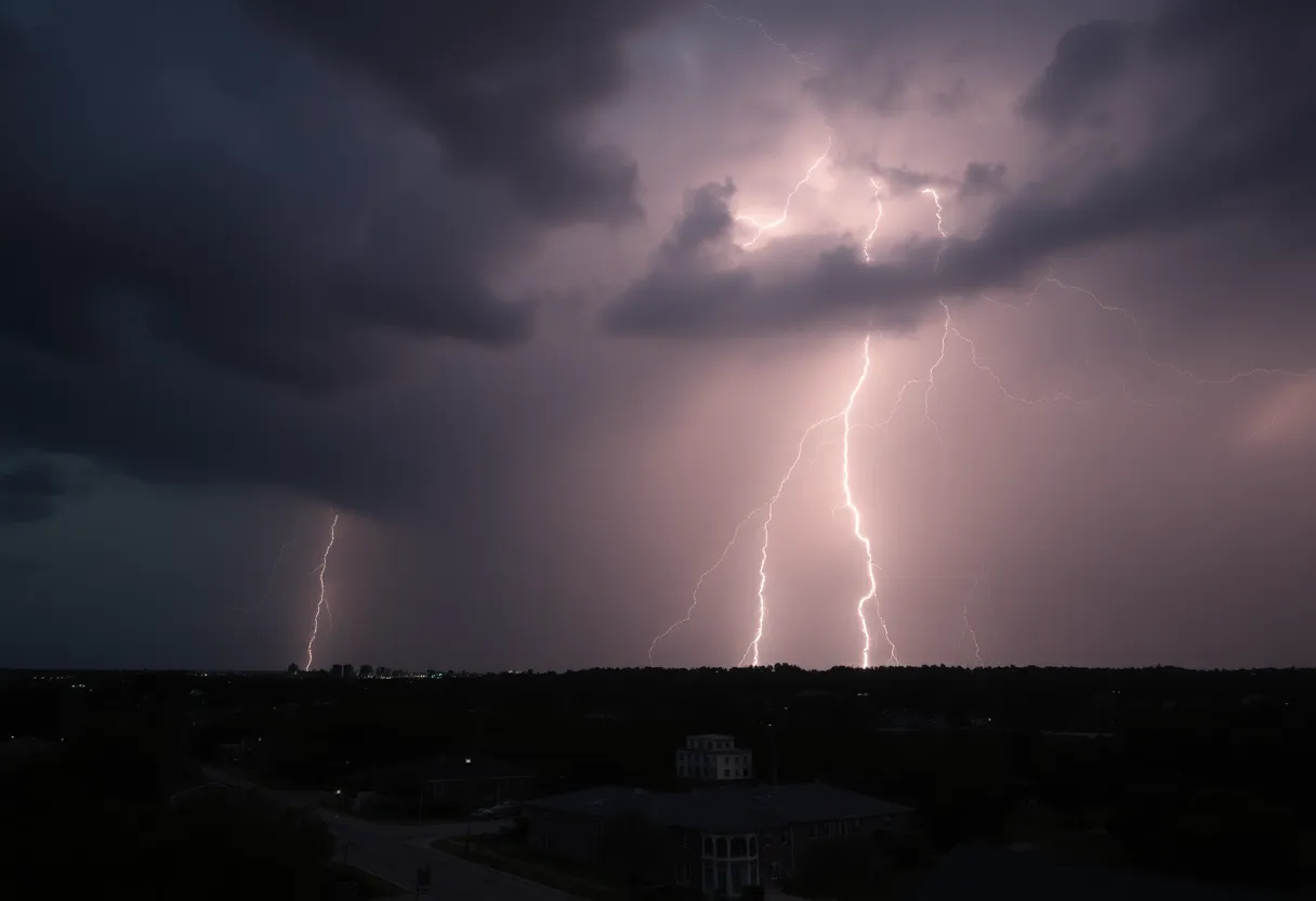
On September 7, severe thunderstorms and flash flood warnings impacted Charleston and nearby counties, with damaging winds and the risk of tornadoes. While the immediate threat decreased in the morning, isolated severe thunderstorms remained a possibility throughout the day. Weather conditions showed high temperatures of 87°F and a 60% chance of rain. The National Weather Service has consistently monitored the situation to ensure public safety.
Charleston
Severe thunderstorms and flash flood warnings significantly impacted the Charleston area on September 7, 2025. The National Weather Service confirmed that most of the severe storms affecting Charleston, Berkeley, and Dorchester Counties have moved out by mid-morning. A severe thunderstorm warning that had been issued for the region expired at 10:45 a.m., shortly after a tornado warning for parts of Charleston was lifted around 10 a.m.
The severe weather began early in the morning when Doppler radar tracked a line of strong storms moving northeast at a speed of 45 mph. These storms originated from a location about six miles south of Cross and advanced over various locations, including Kiawah Island. Although the immediate threat from these storms has diminished, isolated severe thunderstorms remain a possibility throughout the day, with damaging winds posing the greatest risk.
Weather Threats and Potential Damage
The primary concern from today’s weather was damaging winds, which could result in damage to roofs, siding, and trees. In addition, there was a risk that fallen trees and branches could disrupt power lines, leading to electricity outages across affected areas. Hail was also a possibility and could potentially damage outdoor objects.
A flash flood warning was initially triggered early in the morning due to overnight storms, affecting portions of Charleston until 12:15 a.m. Additionally, while weather conditions included cloudy skies early on, scattered thunderstorms developed as the day progressed. The high temperature for the day reached 87°F, with winds from the north-northeast at 5 to 10 mph. The chance of rain was reported at 60%, and the temperature was expected to drop to a low of 67°F later in the evening with a continued 50% chance of rain.
Summary of Warnings and Weather Events
- Severe thunderstorm warning for Charleston, Berkeley, Dorchester, and Colleton Counties expired at 10:45 a.m.
- Previous warning for Beaufort County expired at 10:15 a.m.
- Tornado warning for Charleston, Colleton, and Beaufort Counties was lifted shortly after 10 a.m.
- High temperature: 87°F; Low temperature: 67°F
- Chance of rain: 60% in the morning; 50% later in the evening
Background Context
Severe thunderstorms and their associated warnings are common in the Tri-County area, particularly during the late summer months. These storms can develop quickly, resulting in high winds, heavy rainfall, and occasionally tornadoes. The National Weather Service consistently monitors weather patterns to provide timely warnings to the public to ensure safety during such occurrences.
FAQ Section
What areas were affected by the severe thunderstorms on September 7, 2025?
Charleston, Berkeley, and Dorchester Counties experienced severe thunderstorms on September 7, 2025.
What was the primary hazard associated with the severe thunderstorms?
The primary hazard was damaging winds, which could cause damage to roofs, siding, and trees.
When did the flash flood warning expire?
The flash flood warning lasted until 12:15 a.m. on September 7, 2025.
What weather conditions were reported during the storms?
Weather conditions included early cloudy skies with scattered thunderstorms developing later, high temperatures of 87°F, and a 60% chance of rain.
Key Weather Features Summary
| Feature | Details |
|---|---|
| Areas Affected | Charleston, Berkeley, Dorchester, Colleton Counties |
| Storm Movement | Northeast at 45 mph |
| Severe Thunderstorm Warning | Expired at 10:45 a.m. |
| Flash Flood Warning Duration | Until 12:15 a.m. |
| Primary Hazard | Damaging Winds |
| High Temperature | 87°F |
| Low Temperature | 67°F |
| Chance of Rain | 60% in the morning; 50% later |
Deeper Dive: News & Info About This Topic
HERE Resources
Flash Flood Warning Issued for Charleston Metro Area
Hurricane Kiko Approaches Hawaii as a Category 4 Storm
Health Concerns Rise for Swimmers in Charleston’s Waterways
Hawaii Braces for Hurricane Kiko: State of Emergency Declared
Charleston Prepares for a Vibrant September
Charleston Adjusts Criteria for Flash Flood Warnings
Charleston Literary Festival Announces Exciting Lineup
Blue Ridge Electric Cooperative Celebrates 85 Years of Service
Charleston Hosts Vibrant Weekend Events: Drifter Fest and More
Charleston Hosts YALLFest’s 15th Anniversary Celebration
Additional Resources
- Count on 2 News
- ABC News 4
- Newsweek
- Fox Weather
- Myrtle Beach Online
- Wikipedia: Severe Thunderstorm Warning
- Google Search: Charleston Weather Alerts
- Google Scholar: Charleston Flash Flood
- Encyclopedia Britannica: Thunderstorm
- Google News: Charleston Weather News

Author: STAFF HERE CHARLESTON
The CHARLESTON STAFF WRITER represents the experienced team at HEREcharleston.com, your go-to source for actionable local news and information in Charleston, Charleston County, and beyond. Specializing in "news you can use," we cover essential topics like product reviews for personal and business needs, local business directories, politics, real estate trends, neighborhood insights, and state news affecting the area—with deep expertise drawn from years of dedicated reporting and strong community input, including local press releases and business updates. We deliver top reporting on high-value events such as the Spoleto Festival USA, Charleston Wine + Food Festival, and the MOJA Festival. Our coverage extends to key organizations like the Charleston Metro Chamber of Commerce and the Charleston Museum, plus leading businesses in tourism and maritime industries that power the local economy such as South Carolina Ports Authority and the Charleston Visitor Center. As part of the broader HERE network, including HEREaiken.com, HEREbeaufort.com, HEREchapin.com, HEREcharleston.com, HEREclinton.com, HEREcolumbia.com, HEREgeorgetown.com, HEREgreenwood.com, HEREgreenville.com, HEREhiltonhead.com, HEREirmo.com, HEREmyrtlebeach.com, HEREnewberry.com, HERErockhill.com, HEREspartanburg.com, HEREaustin.com, HEREcollegestation.com, HEREdallas.com, HEREhouston.com, and HEREsanantonio.com, we provide comprehensive, credible insights into South Carolina's dynamic landscape.