Charleston, SC, August 2, 2025
News Summary
Charleston, SC, is preparing for severe thunderstorms this afternoon, according to the National Weather Service. Rainfall and potential flooding are expected in the Tri-County area, affecting North Charleston, Summerville, and Goose Creek. Emergency alerts are in place until 10 PM, warning residents of dangerous conditions such as damaging winds and hydroplaning. Residents are urged to stay indoors and avoid windows during storms to ensure safety.
Charleston, SC is bracing for severe thunderstorms this afternoon, following an updated weather report issued by the National Weather Service (NWS) early today. The report anticipates significant rainfall and potential flooding in the Tri-County area, including parts of North Charleston, Summerville, and Goose Creek.
The weather forecast indicates cloudy skies throughout the morning, with scattered showers and thunderstorms expected to develop in the afternoon. Residents should prepare for heavy rainfall as temperatures reach a high near 85°F. Winds are forecasted to come from the north-northeast at speeds of 5 to 10 mph, with a 50% chance of rain in the early hours transitioning to a 60% chance overnight.
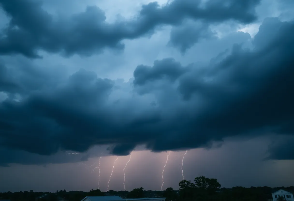
Emergency alerts have been issued for several areas under severe thunderstorm warnings, including Moncks Corner, Ladson, Bonneau, and others. These warnings will remain in effect until 10 PM tonight. The NWS has tracked a strong thunderstorm over Pinopolis moving southeast at approximately 20 mph, and Doppler radar shows storms moving northeast at 45 mph from Cross to Kiawah Island.
Conditions are likely to worsen as isolated severe thunderstorms may produce damaging winds that could affect local infrastructure. Residents are advised to be vigilant, as gusty winds could lead to fallen branches and trees that might disrupt power services. Continuous reports of cloud-to-ground lightning have also been documented, further heightening safety concerns.
In addition to the immediate weather threats, the NWS warns of the risk of hydroplaning on wet roads, which could lead to vehicular accidents and loss of control. Motorists are urged to exercise caution and stay alert during heavy rainfall. For personal safety during thunderstorms, individuals are advised to seek shelter indoors and avoid proximity to windows.
This forecast follows several earlier severe thunderstorm warnings for Charleston, Berkeley, Dorchester, and Colleton Counties that have since expired. The weather’s impact is expected to continue throughout the evening hours, with occasional showers persisting into the night and an overnight low near 71°F.
The public is encouraged to stay informed of weather conditions and advisories as this situation develops. Staying indoors is the recommended precaution during the storms, considering the potential for severe weather events to escalate quickly. The NWS has reiterated its commitment to providing timely updates for community safety during adverse weather events.
Weather Outlook Summary
- High Temperature: Near 85°F
- Chance of Rain: 50% increasing to 60% overnight
- Thunderstorm Warnings: Effective until 10 PM for specified areas
- Wind Speed: NNE at 5-10 mph
- Overnight Low: Near 71°F with occasional showers
Safety Recommendations
- Seek shelter indoors during thunderstorms.
- Avoid windows and stay away from conductive objects.
- Exercise caution when driving on wet roads to prevent hydroplaning.
Frequently Asked Questions
What areas are affected by the severe thunderstorm warning?
The severe thunderstorm warnings affect North Charleston, Summerville, Goose Creek, Moncks Corner, Ladson, Bonneau, Pinopolis, Southern Lake Moultrie, Old Santee Canal State Park, and Bonneau Beach.
What are the expected weather conditions today?
Cloudy skies are expected in the morning with scattered showers and thunderstorms likely to develop in the afternoon. Heavy rainfall and gusty winds are also anticipated.
How can I stay safe during the severe weather?
Seek indoor shelter, avoid windows, and be mindful of driving conditions to prevent accidents due to hydroplaning on wet roads.
Key Features of Today’s Weather Update
| Feature | Details |
|---|---|
| Warnings | Severe thunderstorms in the Tri-County area until 10 PM |
| Rain Probability | 50% in the afternoon, increasing to 60% overnight |
| Temperature | High of 85°F, Low near 71°F |
| Wind | NNE at 5 to 10 mph |
| Safety Risk | Hydroplaning and lightning strikes |
Deeper Dive: News & Info About This Topic
HERE Resources
Charleston’s Upcoming Literary Festival Featuring Acclaimed Authors
Charleston Issues Severe Thunderstorm Warning Amid Weather Risks
Sullivan’s Island Residents Push for Dredging of Cove Creek
Toronto Blue Jays Seek Redemption Against Baltimore Orioles
North Charleston Family Faces Distress After Immigration Detainment
Otranto Road Reopens After Utility Pole Collision
Charleston Embraces Dog-Friendly Summer Activities
Charleston Commences Major Recreation Projects
North Charleston Man Sentenced After Fatal Hit-and-Run
Charleston Hosts Casting Call for Love is Blind
Additional Resources
- Herald Online: Thunderstorm Update
- Wikipedia: Thunderstorm
- Weather.com: Charleston Weather
- Google Search: Charleston SC Weather
- Island Packet: Severe Weather Report
- Google Scholar: Severe Thunderstorm Warning
- Live 5 News: Lowcountry Thunderstorm Warning
- Encyclopedia Britannica: Thunderstorm
- ABC News 4: Severe Thunderstorm Warning
- Google News: Charleston Thunderstorm

Author: STAFF HERE CHARLESTON
The CHARLESTON STAFF WRITER represents the experienced team at HEREcharleston.com, your go-to source for actionable local news and information in Charleston, Charleston County, and beyond. Specializing in "news you can use," we cover essential topics like product reviews for personal and business needs, local business directories, politics, real estate trends, neighborhood insights, and state news affecting the area—with deep expertise drawn from years of dedicated reporting and strong community input, including local press releases and business updates. We deliver top reporting on high-value events such as the Spoleto Festival USA, Charleston Wine + Food Festival, and the MOJA Festival. Our coverage extends to key organizations like the Charleston Metro Chamber of Commerce and the Charleston Museum, plus leading businesses in tourism and maritime industries that power the local economy such as South Carolina Ports Authority and the Charleston Visitor Center. As part of the broader HERE network, including HEREaiken.com, HEREbeaufort.com, HEREchapin.com, HEREcharleston.com, HEREclinton.com, HEREcolumbia.com, HEREgeorgetown.com, HEREgreenwood.com, HEREgreenville.com, HEREhiltonhead.com, HEREirmo.com, HEREmyrtlebeach.com, HEREnewberry.com, HERErockhill.com, HEREspartanburg.com, HEREaustin.com, HEREcollegestation.com, HEREdallas.com, HEREhouston.com, and HEREsanantonio.com, we provide comprehensive, credible insights into South Carolina's dynamic landscape.