Charleston, South Carolina, October 11, 2025
News Summary
Charleston, South Carolina, faces a coastal flood advisory issued by the National Weather Service. Residents should be aware of high tides and potential flooding, with water levels expected to reach between 7.7 to 7.9 feet. Numerous roads may become impassable and precautions are advised for those in flood-prone areas. The city has opened parking garages for residents and is actively clearing storm drains to manage the flooding threat.
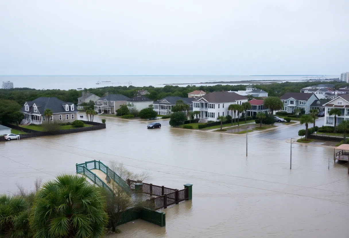
Charleston, South Carolina is under a coastal flood advisory as the National Weather Service (NWS) issued a warning late Friday night. The advisory is active from 10 a.m. to 2 p.m. on Saturday, affecting Coastal Colleton and Charleston County. The area is expected to experience inundation of up to one foot above ground level along shorelines and tidal waterways, with water levels anticipated to reach between 7.7 to 7.9 feet Mean Lower Low Water in Charleston.
High tide is predicted to occur around 12:01 p.m. on Saturday, raising concerns about saltwater inundation that may occur one to two hours before and after the high tide. Residents should be aware that numerous roads could become impassable, and some properties may face minor flooding as a result. The NWS has reported dangerous swimming and surfing conditions, alongside localized beach erosion.
There is an increased risk of rip currents, particularly dangerous for swimmers. Travelers are advised to allow extra time for potential road closures and to avoid driving around barricades or through water of unknown depth. Those living in flood-prone or low-lying areas are urged to seek higher ground immediately.
In the case of necessitating evacuation, residents should do so without delay while securely locking their homes. If there’s enough time, it is recommended to disconnect utilities and appliances prior to leaving. Caution is advised against entering basements or using rooms with submerged electrical outlets or cords. Residents should evacuate immediately if any signs of danger, such as sparks or buzzing sounds, are noted.
Additionally, pedestrians should refrain from walking through floodwaters, as even six inches of swiftly moving water can knock an individual off their feet. If trapped by moving water, seeking higher ground and contacting emergency services is crucial. Flooding risks significantly increase during heavy rainfall, particularly in low-lying regions. Just 12 inches of rushing water can sweep vehicles away, and hydroplaning can occur when vehicles slide uncontrollably due to water accumulation on the roads.
The Charleston Harbor has already reached a Major Flood Stage Level of 8 feet just before the upcoming high tide, with flooding typically commencing in the city at the 7-foot level. As a result, multiple roads in downtown Charleston are closed due to flooding, and a coastal flood warning remains in effect.
In response to the flooding threat, the city of Charleston has opened two city-owned parking garages where residents can park free of charge until 4 p.m. on Friday. Residents are strongly encouraged to take the risk of flooding seriously, especially with severe weather affecting morning commutes. Wind gusts between 30 to 35 mph are also expected to continue from Thursday night into Saturday, leading to a small craft advisory. The city is taking proactive measures to clear storm drains and ditches in areas known for flooding issues.
Frequently Asked Questions
What is the duration of the coastal flood advisory in Charleston?
The advisory is valid from 10 a.m. to 2 p.m. for Coastal Colleton and Charleston County.
What are the expected water levels during the high tide?
Water levels are anticipated to reach between 7.7 to 7.9 feet Mean Lower Low Water in Charleston.
What precautions should residents take in flood-prone areas?
Residents in flood-prone areas should move to higher ground immediately and evacuate if necessary.
Are there any risks associated with walking or driving through floodwaters?
Yes, even six inches of swiftly moving water can knock a person off their feet, and just 12 inches can sweep vehicles away.
What is being done by the city to manage the flooding situation?
The city is actively working to clear storm drains and ditches in known problem areas.
Key Features of the Coastal Flood Advisory
| Feature | Details |
|---|---|
| Advisory Duration | 10 a.m. to 2 p.m. on Saturday |
| Expected Water Levels | 7.7 to 7.9 feet Mean Lower Low Water in Charleston |
| High Tide Time | 12:01 p.m. on Saturday |
| Road Conditions | Multiple roads closed due to flooding |
| Wind Gusts | 30 to 35 mph expected |
| City Response | Clearing storm drains and ditches, free parking in city garages until 4 p.m. on Friday |
Deeper Dive: News & Info About This Topic
HERE Resources
Nor’easter Impacts East Coast with Flooding and High Winds
Charleston Police Announce Road Closures for Citadel Home Game
Downtown Charleston Faces Severe Coastal Flooding
Coastal Flooding Hits Downtown Charleston
Remembering Davis William Reeves
FirstService Residential Promotes McLaurin Bruce to Business Development Director
Coastal Flood Warning Issued for Charleston
Charleston Under Coastal Flood Warning as King Tides Hit
Charleston Prepares for Major Coastal Flooding During High Tides
Charleston County School District Abolishes Constituent Boards
Additional Resources
- The State: Coastal Flood Advisory in Charleston
- Wikipedia: Flood
- Island Packet: Weather News
- Google Search: Charleston flooding
- Live 5 News: Tidal Flooding Threat
- Google Scholar: Coastal flooding Charleston
- Fox Weather: Coastal Flooding Update
- Encyclopedia Britannica: Coastal flooding
- ABC News 4: Coastal Flooding Road Closures
- Google News: Charleston weather

Author: STAFF HERE CHARLESTON
The CHARLESTON STAFF WRITER represents the experienced team at HEREcharleston.com, your go-to source for actionable local news and information in Charleston, Charleston County, and beyond. Specializing in "news you can use," we cover essential topics like product reviews for personal and business needs, local business directories, politics, real estate trends, neighborhood insights, and state news affecting the area—with deep expertise drawn from years of dedicated reporting and strong community input, including local press releases and business updates. We deliver top reporting on high-value events such as the Spoleto Festival USA, Charleston Wine + Food Festival, and the MOJA Festival. Our coverage extends to key organizations like the Charleston Metro Chamber of Commerce and the Charleston Museum, plus leading businesses in tourism and maritime industries that power the local economy such as South Carolina Ports Authority and the Charleston Visitor Center. As part of the broader HERE network, including HEREaiken.com, HEREbeaufort.com, HEREchapin.com, HEREcharleston.com, HEREclinton.com, HEREcolumbia.com, HEREgeorgetown.com, HEREgreenwood.com, HEREgreenville.com, HEREhiltonhead.com, HEREirmo.com, HEREmyrtlebeach.com, HEREnewberry.com, HERErockhill.com, HEREspartanburg.com, HEREaustin.com, HEREcollegestation.com, HEREdallas.com, HEREhouston.com, and HEREsanantonio.com, we provide comprehensive, credible insights into South Carolina's dynamic landscape.