Charleston, August 14, 2025
News Summary
Charleston, South Carolina has experienced significant flash flooding due to heavy rain and high tide, leading to numerous road closures and disruptions across downtown and surrounding areas. A Flash Flood Watch remains in effect as forecasts predict additional rainfall. Emergency services have adjusted operations, urging residents to avoid road travel during this hazardous situation. The ongoing rain and ground saturation create an environment especially susceptible to flooding, raising concerns over potential severe weather from Tropical Storm Erin.
Charleston Faces Flash Flooding and Road Closures
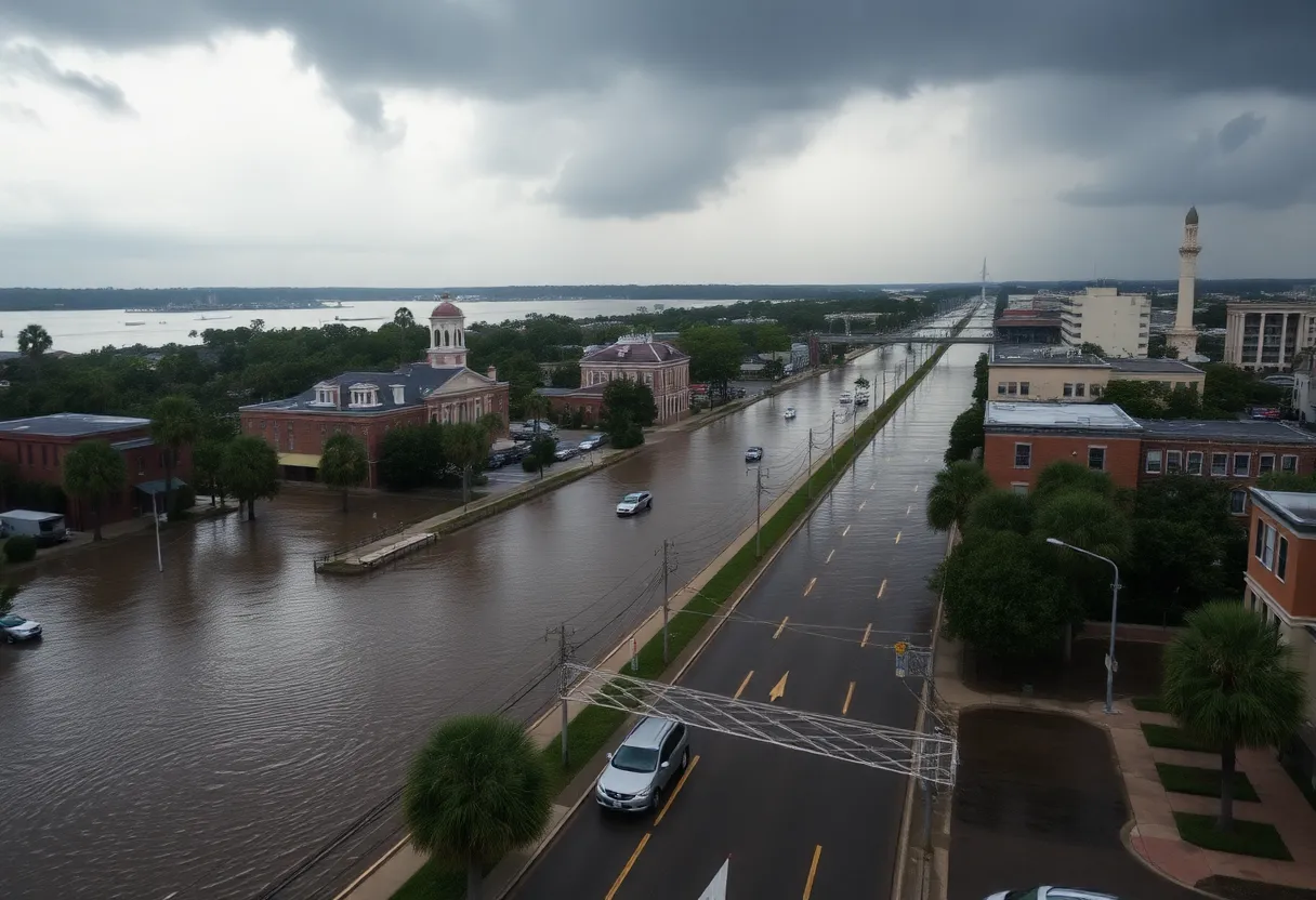
Charleston, South Carolina has been hit by flash flooding, leading to significant road closures and disruptions across the downtown area and surrounding communities. A Flash Flood Watch was issued as heavy rain and high tide affected local roadways, creating dangerous conditions for residents.
The National Weather Service (NWS) reported that as of noon on August 11, 2025, over an inch of rain fell in the region, with forecasts predicting an additional rainfall of up to 3 inches due to thunderstorms affecting the area. This weather phenomenon is expected to continue, with flash flooding warnings remaining in effect until at least 3:15 p.m. today.
In response to the severe flooding, Charleston County Emergency Medical Services (EMS) adjusted their operations, advising that patients needing transport be taken to the closest appropriate hospital as many roads became impassable. Officials strongly urged residents to remain off the roads until floodwaters recede to avert potential risks associated with driving or wading through flooded areas.
By late morning, more than a dozen roads had been closed in downtown Charleston, with police reporting that 29 streets were temporarily classified as “underwater.” This is a marked improvement compared to past flood events when nearly 60 roads were closed. Areas heavily impacted by the current flooding include North Charleston, Mount Pleasant, Daniel Island, West Ashley, and the Charleston Naval Complex.
The flooding is exacerbated by a combination of heavy rainfall and the ongoing high tide, which has led to flooding conditions that officials have described as concerning but manageable considering historical data. Despite the current severity, Charleston has recorded only 26.7 inches of rain since the start of the year, falling short of the average 31.4 inches for this period. Comparatively, downtown Charleston has seen 21 inches of rain so far this year, down from the 25 inches recorded by this date last year.
Officials noted that the ground saturation had been built up over several days of consistent rain, creating an environment particularly susceptible to flash flooding. Moreover, the region may be preparing for more extreme weather as Tropical Storm Erin is forecasted to potentially develop into a significant hurricane, heightening anxiety over additional rainfall in the Lowcountry.
According to the NWS, slow-moving storms could result in rainfall rates exceeding 2 inches per hour, and the potential for flash flooding will continue along the Carolina coast into early Tuesday morning. The storm patterns are projected to shift towards the southern Appalachians by mid-week.
Key Impacts
- Flash Flood Watch issued for downtown Charleston.
- Heavy rain and thunderstorms affecting the region.
- Over a dozen roads closed, police reporting 29 streets under water.
- EMS modified operations due to accessibility issues.
- Predicted rainfall may reach up to 3 inches in additional storms.
Background Context
Despite the perception of heavy rainfall, Charleston has seen notably below-average precipitation this year, impacted heavily by Hurricane Debby last year, which contributed to extensive rainfall. The community has experienced a series of weather events over the past week, and city officials are closely monitoring the situation as they prepare for potential further developments from Tropical Storm Erin.
FAQ
What caused the flash flooding in Charleston?
The flash flooding was caused by a combination of heavy rain and high tide, resulting in significant water accumulation on roadways.
How much rain has fallen during the flooding?
Over an inch of rain had fallen by noon on August 11, with forecasts predicting additional rainfall of up to 3 inches.
Which areas are impacted by the flooding?
Flooding has significantly affected downtown Charleston, North Charleston, Mount Pleasant, Daniel Island, West Ashley, and the Charleston Naval Complex.
What should residents do during a flash flood?
Residents are advised to stay off the roads until floodwaters recede and to avoid driving or walking through flooded areas.
Is this flooding unusual for Charleston?
While flash flooding can occur, this year the area has seen below-average rainfall, although ground saturation from prior rains contributed to current flooding conditions.
Key Features
| Feature | Details |
|---|---|
| Issued Watch | Flash Flood Watch for downtown Charleston |
| Rainfall Amount | Over 1 inch fell by noon; additional 1-3 inches expected |
| Road Closures | Over a dozen roads closed; 29 streets reported underwater |
| EMS Operations | Modified due to accessibility issues |
| Concern Areas | Downtown Charleston, North Charleston, Mount Pleasant, Daniel Island, West Ashley, Charleston Naval Complex |
| Forecast | Continued threat of flash flooding into Tuesday; potential for storms to shift mid-week |
Deeper Dive: News & Info About This Topic
HERE Resources
Charleston City Councilwoman Caroline Parker Declines Reelection Bid
Record Flooding in Juneau Mitigated by Emergency Barriers
Alaska Governor Declares Disaster Due to Flooding Threat
Historic Flooding Hits Milwaukee After Weekend Storm
Severe Thunderstorms Expected in Charleston Area with High Winds and Heavy Rainfall
Severe Storms and Record Flooding Hit Wauwatosa, Wisconsin
Charleston County Prepares for Municipal Elections
Charleston, South Carolina Implements New Flood Warning Criteria
Charleston Faces Severe Thunderstorm Threat and Marker Restoration
Literary Pool Party at Isle of Palms Encourages Reading
Additional Resources
- Count On 2 News
- Google Search: Charleston flash flooding
- ABC News 4
- Wikipedia: Flash Flood
- Post and Courier
- Google Scholar: Flash Flooding in Charleston
- Live 5 News
- Encyclopedia Britannica: Flood
- Herald Online
- Google News: Charleston flooding

Author: STAFF HERE CHARLESTON
The CHARLESTON STAFF WRITER represents the experienced team at HEREcharleston.com, your go-to source for actionable local news and information in Charleston, Charleston County, and beyond. Specializing in "news you can use," we cover essential topics like product reviews for personal and business needs, local business directories, politics, real estate trends, neighborhood insights, and state news affecting the area—with deep expertise drawn from years of dedicated reporting and strong community input, including local press releases and business updates. We deliver top reporting on high-value events such as the Spoleto Festival USA, Charleston Wine + Food Festival, and the MOJA Festival. Our coverage extends to key organizations like the Charleston Metro Chamber of Commerce and the Charleston Museum, plus leading businesses in tourism and maritime industries that power the local economy such as South Carolina Ports Authority and the Charleston Visitor Center. As part of the broader HERE network, including HEREaiken.com, HEREbeaufort.com, HEREchapin.com, HEREcharleston.com, HEREclinton.com, HEREcolumbia.com, HEREgeorgetown.com, HEREgreenwood.com, HEREgreenville.com, HEREhiltonhead.com, HEREirmo.com, HEREmyrtlebeach.com, HEREnewberry.com, HERErockhill.com, HEREspartanburg.com, HEREaustin.com, HEREcollegestation.com, HEREdallas.com, HEREhouston.com, and HEREsanantonio.com, we provide comprehensive, credible insights into South Carolina's dynamic landscape.