Charleston, S.C., August 16, 2025
News Summary
Charleston, S.C. is under a flash flood warning as heavy rainfall coincides with high tide. Areas affected include Mount Pleasant, Isle of Palms, and Sullivan’s Island. Residents are advised to seek higher ground, avoid travel, and stay updated on weather alerts as flooding impacts road conditions.
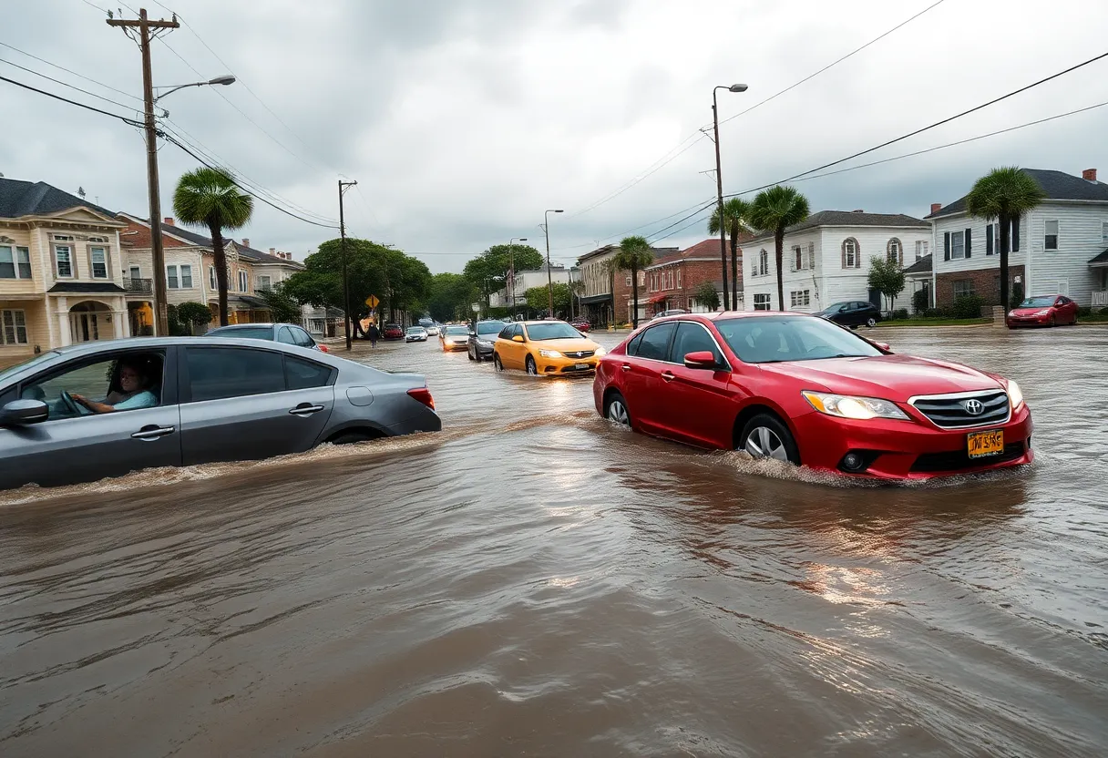
Charleston, S.C. is currently under a flash flood warning as heavy rain moves into the area, coinciding with the morning high tide. The warning is in effect for portions of Charleston County, including Mount Pleasant, Isle of Palms, and Sullivan’s Island, until 3:15 p.m. In addition, a flood advisory is applicable for Downtown Charleston until 2:45 p.m.
The National Weather Service (NWS) has issued the warnings due to expected localized flooding, particularly in low-lying or poorly drained areas. As of 9:30 a.m., at least 0.5 inches of rain had already fallen, with forecasts predicting an additional 1 to 2 inches. Slow-moving thunderstorms may exacerbate the situation, potentially dropping over two inches of rainfall per hour.
More than a dozen roads in Downtown Charleston have been closed due to flooding. Charleston County Emergency Medical Services are operating under modified conditions, prioritizing patients to the nearest appropriate hospital only due to the hazardous road conditions. Residents are advised to avoid traveling until floodwaters recede and to refrain from driving or wading through flooded streets.
Evacuation instructions have been issued for residents and campers located in flood-prone areas, advising them to seek higher ground. Individuals are cautioned against entering basements or rooms with submerged electrical outlets and should evacuate immediately if they hear any sparks or electrical sounds. The risk of hydroplaning is increased during this time, as water can accumulate in front of vehicle tires, making driving perilous.
The flooding issues are compounded by ground saturation from previous rainfall over the weekend, which recorded approximately two inches. Forecast models indicate that the storm threat will persist through early Tuesday morning before shifting to the southern Appalachians later in the week.
Key Information
- Flash Flood Warning: In effect until 3:15 p.m. for Mount Pleasant, Isle of Palms, Sullivan’s Island.
- Flood Advisory: In effect until 2:45 p.m. for Downtown Charleston.
- Rainfall: 0.5 inches recorded, with an additional 1-2 inches expected.
- Flooded Roads: Over a dozen closed in Downtown Charleston.
- Emergency Services: Adjusted protocol to transport patients only to the closest hospital.
- Evacuation Advice: Seek higher ground in flood-prone areas.
Public Safety Measures
Residents are urged to remain indoors, especially in low-lying areas where water accumulation is more severe. It is vital to stay updated on weather alerts and follow local authorities for real-time information. In anticipation of potential evacuation, families should prepare an emergency kit and discuss evacuation plans.
Community Response
The local government and emergency services are actively monitoring the situation. Preparations are underway to assist residents affected by flooding, and they are working to clear affected roadways to maintain accessibility as conditions improve. Continuous assessments will be made throughout the rainfall period to ensure public safety.
Looking Ahead
As forecasts indicate prolonged rainfall and possible flooding through Tuesday, the community is advised to remain alert and prepared for further weather developments. This situation serves as a reminder of Charleston’s vulnerability to flooding, particularly during storm events exacerbated by existing weather conditions.
FAQ
What areas are affected by the flash flood warning?
Mount Pleasant, Isle of Palms, Sullivan’s Island, and parts of Downtown Charleston are under the flash flood warning.
How much rain has fallen and how much is expected?
At least 0.5 inches of rain has fallen, with an additional 1 to 2 inches expected throughout the day.
What should residents do during the warning?
Residents should avoid unnecessary travel, seek higher ground if in flood-prone areas, and stay updated on weather alerts.
Are emergency services still operational?
Yes, but they are operating under modified protocols due to the road conditions, prioritizing transport to the nearest appropriate hospital.
When is the storm expected to pass?
The storm threat is expected to continue through early Tuesday morning before moving to the southern Appalachians later in the week.
Key Features Overview
| Feature | Description |
|---|---|
| Flash Flood Warning | In effect until 3:15 p.m. for affected areas. |
| Flood Advisory | Applicable until 2:45 p.m. for Downtown Charleston. |
| Rainfall | 0.5 inches recorded; additional 1-2 inches expected. |
| Road Conditions | Over a dozen roads closed due to flooding. |
| Emergency Services | Modified transport protocols in effect due to flooding. |
| Evacuation Guidance | Seek higher ground; avoid basements or submerged areas. |
Deeper Dive: News & Info About This Topic
HERE Resources
Charleston Faces Severe Thunderstorms and Flash Flooding
Hurricane Erin Begins Impacting Atlantic Region
Sarah Spangler Announces Candidacy for Charleston City Council
Charleston Faces Flash Flooding and Road Closures
Severe Thunderstorms Expected in Charleston Area with High Winds and Heavy Rainfall
Severe Storms and Record Flooding Hit Wauwatosa, Wisconsin
Charleston, South Carolina Implements New Flood Warning Criteria
Charleston Faces Severe Thunderstorm Threat and Marker Restoration
Mount Pleasant Preserves Historic Coakley Chapel and Establishes New Park
Severe Thunderstorm Warning for Charleston Area
Additional Resources
- Island Packet
- Wikipedia: Flash Flood
- Fox Weather
- Google Search: Charleston flooding
- Count on 2
- Encyclopedia Britannica: Flood
- ABC News 4
- Google News: Charleston S.C. flood
- Herald Online

Author: STAFF HERE CHARLESTON
The CHARLESTON STAFF WRITER represents the experienced team at HEREcharleston.com, your go-to source for actionable local news and information in Charleston, Charleston County, and beyond. Specializing in "news you can use," we cover essential topics like product reviews for personal and business needs, local business directories, politics, real estate trends, neighborhood insights, and state news affecting the area—with deep expertise drawn from years of dedicated reporting and strong community input, including local press releases and business updates. We deliver top reporting on high-value events such as the Spoleto Festival USA, Charleston Wine + Food Festival, and the MOJA Festival. Our coverage extends to key organizations like the Charleston Metro Chamber of Commerce and the Charleston Museum, plus leading businesses in tourism and maritime industries that power the local economy such as South Carolina Ports Authority and the Charleston Visitor Center. As part of the broader HERE network, including HEREaiken.com, HEREbeaufort.com, HEREchapin.com, HEREcharleston.com, HEREclinton.com, HEREcolumbia.com, HEREgeorgetown.com, HEREgreenwood.com, HEREgreenville.com, HEREhiltonhead.com, HEREirmo.com, HEREmyrtlebeach.com, HEREnewberry.com, HERErockhill.com, HEREspartanburg.com, HEREaustin.com, HEREcollegestation.com, HEREdallas.com, HEREhouston.com, and HEREsanantonio.com, we provide comprehensive, credible insights into South Carolina's dynamic landscape.