News Summary
The National Weather Service has issued a weather alert for strong thunderstorms impacting Dorchester and Charleston counties. Residents are advised to stay informed about potential hazards, including damaging winds and increased lightning risk. Monitoring local updates is crucial as isolated severe thunderstorms may continue throughout the week.
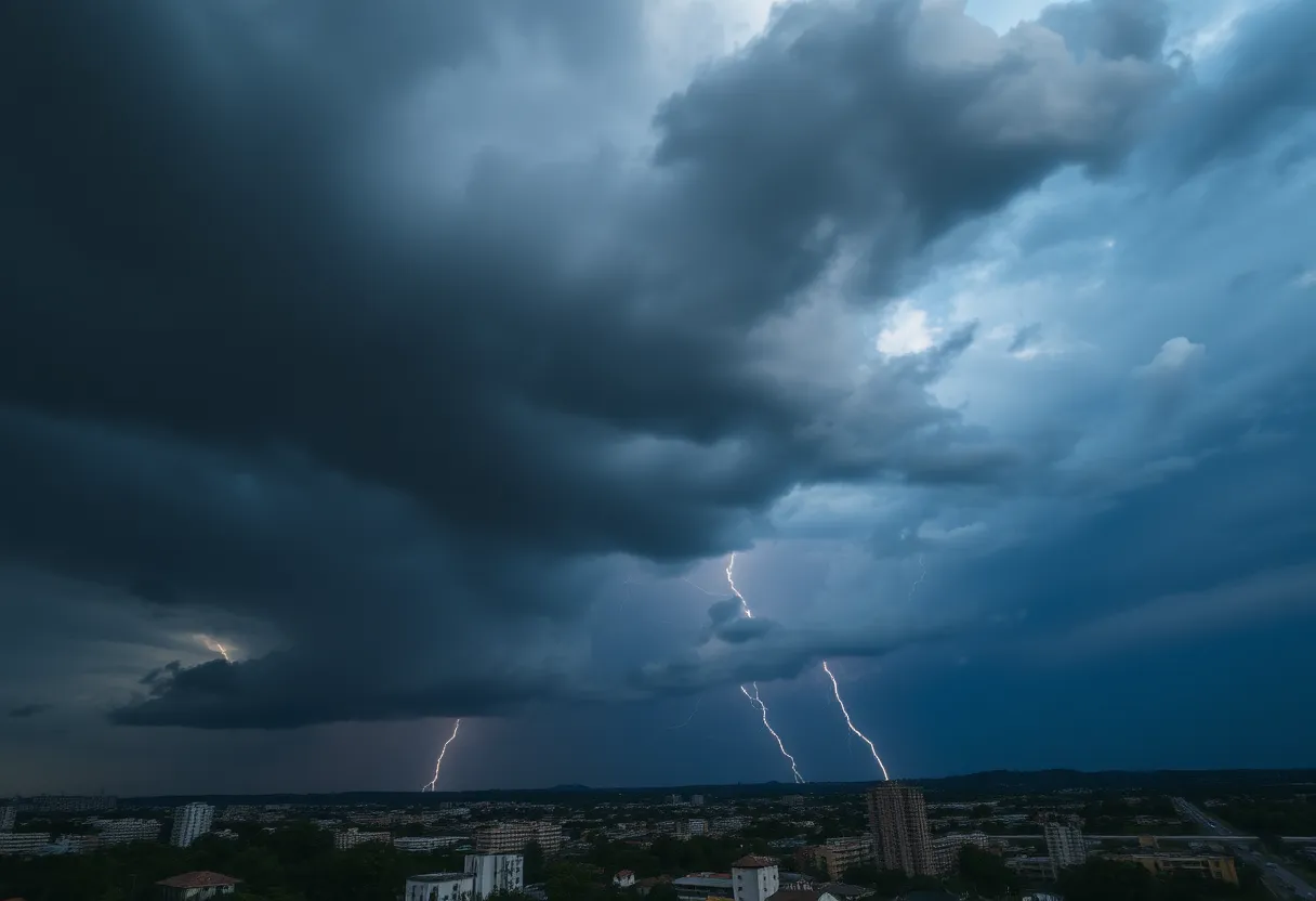
Charleston – The National Weather Service (NWS) issued an updated weather alert on Monday at 3:47 p.m. for strong thunderstorms affecting Dorchester and Charleston counties until 4:30 p.m. Doppler radar detected a strong thunderstorm positioned five miles north of Delemar Crossroads at the time the alert was generated. The storm is reported to be nearly stationary, raising concerns about potential damage in the affected areas.
Impact and Locations Affected
Residents in several locations could experience the effects of the storm, which include:
- Summerville
- Delemar Crossroads
- Knightsville
- Clubhouse Crossroads
- Canaan
- Westoe
- Sland Bridge
- Slandsville
- Cooke Crossroads
- Gettysville
The NWS has advised individuals in these areas to monitor updates via NOAA Weather Radio All Hazards, television broadcasts, or local news sources for the latest developments regarding the storm.
Potential Dangers
Gusty winds from the thunderstorm may pose additional risks, including the possibility of knocking down tree limbs and moving unsecured objects. These strong winds could lead to hazardous situations, such as property damage and power outages.
Furthermore, the primary threats posed by these thunderstorms include damaging winds capable of uprooting trees and damaging roofs, as well as hail that could harm outdoor possessions. The risk of lightning is also heightened; the United States experiences approximately 25 million lightning strikes annually, with around 20 fatalities each year linked to these incidents. As thunderstorms approach, the chance of lightning strikes increases.
Previous Weather Alerts
Earlier in the day, severe thunderstorms had already impacted the Tri-County area—Charleston, Berkeley, and Dorchester counties—until approximately 11:45 a.m. A formal severe thunderstorm warning in this region had expired before the issuance of the new alert. Doppler radar had earlier indicated a line of strong storms moving northeast at 45 mph, originating around six miles south of Kiawah Island. While major severe storm activity has since diminished, isolated severe thunderstorms remain a possibility for Tuesday.
Driving Precautions
Driving conditions could also worsen due to wet roads. Hydroplaning is a prevalent risk during storms and occurs when water builds up in front of a tire, causing a loss of traction. Factors such as the intensity of the rain and the speed of the vehicle contribute to the likelihood of hydroplaning. To combat this risk, drivers should familiarize themselves with best practices to regain control of their vehicles if hydroplaning occurs.
Conclusion
Residents of Charleston and Dorchester counties are urged to remain vigilant as severe weather continues to threaten the area. The NWS suggests staying informed about the development of thunderstorms and potential hazards. Preparing for possible power outages and staying indoors during severe weather can help ensure safety amid the unpredictable conditions.
Deeper Dive: News & Info About This Topic
HERE Resources
Severe Thunderstorm Alerts Issued for Charleston Area
North Charleston Opens Cooling Center Amid Heatwave
Charleston Leaders Seek Grant for Flood Prevention Project
Severe Weather Impacts Millions Across the U.S. This Weekend
Charleston’s Concert Scene Transitions to Digital Ticketing
Michigan Lawyer Introduces Reduced Fees for Accident Victims
Charleston Set to Host Music and Community Events
Flood Advisory Issued for Charleston County Amid Severe Weather
Unions Challenge New Jersey Attorney General in Racial Profiling Lawsuit
Severe Thunderstorm Warning Issued for Charleston and Berkeley Counties
Additional Resources
- Live 5 News: Thunderstorm Warning
- Wikipedia: Thunderstorm
- ABC News 4: Severe Thunderstorm Warning
- Google Search: Thunderstorm Warning Charleston
- Count On 2: Tornado Warning
- Google Scholar: Thunderstorm Impact
- The State: Weather News Article
- Encyclopedia Britannica: Weather
- WV Metro News: Severe Thunderstorm Watch
- Google News: Thunderstorm Charleston

Author: STAFF HERE CHARLESTON
The CHARLESTON STAFF WRITER represents the experienced team at HEREcharleston.com, your go-to source for actionable local news and information in Charleston, Charleston County, and beyond. Specializing in "news you can use," we cover essential topics like product reviews for personal and business needs, local business directories, politics, real estate trends, neighborhood insights, and state news affecting the area—with deep expertise drawn from years of dedicated reporting and strong community input, including local press releases and business updates. We deliver top reporting on high-value events such as the Spoleto Festival USA, Charleston Wine + Food Festival, and the MOJA Festival. Our coverage extends to key organizations like the Charleston Metro Chamber of Commerce and the Charleston Museum, plus leading businesses in tourism and maritime industries that power the local economy such as South Carolina Ports Authority and the Charleston Visitor Center. As part of the broader HERE network, including HEREaiken.com, HEREbeaufort.com, HEREchapin.com, HEREcharleston.com, HEREclinton.com, HEREcolumbia.com, HEREgeorgetown.com, HEREgreenwood.com, HEREgreenville.com, HEREhiltonhead.com, HEREirmo.com, HEREmyrtlebeach.com, HEREnewberry.com, HERErockhill.com, HEREspartanburg.com, HEREaustin.com, HEREcollegestation.com, HEREdallas.com, HEREhouston.com, and HEREsanantonio.com, we provide comprehensive, credible insights into South Carolina's dynamic landscape.